Antike Landkarten kaufen
183 Los(e)
- Liste
- Galerie
-
183 Los(e)/Seite


Highlight
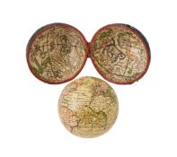
A FINE GEORGE II 2.75 INCH TERRESTRIAL POCKET GLOBE NATHANIEL HILL, LONDON, PUBLISHED 1754 The sphere applied with twelve hand colou...

λ ITHELL COLQUHOUN (BRITISH 1903-1988) CHURCH INTERIOR Pencil and watercolour Signed and dated 38 (upper left) 40.5 x 56cm (15¾...

Los 382
ACADEMY AWARD NOMINEES: (x7)
ACADEMY AWARD NOMINEES: A good selection of signed colour 8 x 10 photographs by various actresses, each of them Best Actress Oscar nominees in the...

Los 1259
MILAN I: (1854-1901)
MILAN I: (1854-1901) King of Serbia 1882-89. A brief A.L.S., Milan, one page, 8vo, n.p., 13/25th November (1887), to [Hugh] Wyndham, on the King's...

Los 1336
ESTRADA PALMA TOMAS: (1835-1908)
ESTRADA PALMA TOMAS: (1835-1908) First President of Cuba 1902-1906, and previously during the Ten Year´s War. Remembered for allowing the Platt Am...

Los 1164
ROUSSELET DE CHATEAURENAULT FRANCOIS LOUIS: (1637-1716) French Vice Admiral and Marshal of France
ROUSSELET DE CHATEAURENAULT FRANCOIS LOUIS: (1637-1716) French Vice Admiral and Marshal of France who saw action in the Franco-Spanish War, the Ni...

Los 883
FRENCH LITERATURE: (x2)
FRENCH LITERATURE: Alexandre Dumas fils (1824-1895) French author and playwright. The personal printed oblong 12mo Visiting Card of Dumas fils, un...

Los 850
SLAVERY - MAURITIUS:
SLAVERY - MAURITIUS: Philippe Jean de la Haye Duponsel (1752-1790) French slave trader established in Mauritius, which was called at that time, ''...

Los 1
Wilhelm Hunt Diederich
Austrian-Hungarian/American, 1884-1953Central Park Zoo: Monkey Cage DesignCharcoal and pastel on paper30 1/4 x 20 3/4 inches (76.8 x 52.7 cm)(Fram...

Los 83
Crimea.- Malby & Sons (publisher) Sevastopol Showing the Position of the Allied Camps and the Bat...
Crimea.- Malby & Sons (publisher) Sevastopol Showing the Position of the Allied Camps and the Batteries, lithographed map with hand-colouring, 680...
![Atlases.- Mudie (Robert) Gilbert's Modern Atlas of the Earth, 56 engraved maps, [c.1840]](https://portal-images.azureedge.net/auctions-2025/forum-10461/images/6e060c66-3216-42ce-a8a3-b291011797cc.jpg?h=175)
Atlases.- Mudie (Robert) Gilbert's Modern Atlas of the Earth, additional wood-engraved pictorial title featuring vignettes of the continents, 2 en...
![Asia.- Japan.- [Gengyo (Seiken)] [Dai-Nihon kaikiru zenzu, or Complete Naval Map of Japan], woodb...](https://portal-images.azureedge.net/auctions-2025/forum-10461/images/67aa01aa-0f99-41c6-b183-b29101178dbb.jpg?h=175)
Los 63
Asia.- Japan.- [Gengyo (Seiken)] [Dai-Nihon kaikiru zenzu, or Complete Naval Map of Japan], woodb...
Asia.- Japan.- [Gengyo (Seiken)] [Dai-Nihon kaikiru zenzu, or Complete Naval Map of Japan], woodblock map printed in colours, sheet 715 x 990 mm (...

Los 61
Asia.- China & Japan.- Fries (Laurent) Ta. Superioris Indiae et Tartariae Maioris, woodcut map, [...
Asia.- China & Japan.- Fries (Laurent) and Claudius Ptolemaeus. Ta. Superioris Indiae et Tartariae Maioris, Fries' map of eastern Asia, the first ...

Los 93
Europe.- France.- Pinkney (Lieutentant-Colonel) Travels through the South of France and in the In...
Europe.- France.- Pinkney (Lieutentant-Colonel) Travels through the South of France and in the Interior of the Provinces of Provence and Languedoc...

Los 74
China.- Huddart (Joseph) A Survey of the Tigris from Canton to the Island of Lankeet, engraved ma...
China.- Huddart (Joseph) A Survey of the Tigris from Canton to the Island of Lankeet, chart showing the Tigris from Guangzhou to the Pearl River ...
![India.- Fries (Laurent) and Claudius Ptolemaeus. Tabula nova vtriusque Indiae, woodcut map, [c.1535]](https://portal-images.azureedge.net/auctions-2025/forum-10461/images/fa624989-a8e2-409a-8f18-b2910117f2f6.jpg?h=175)
Los 113
India.- Fries (Laurent) and Claudius Ptolemaeus. Tabula nova vtriusque Indiae, woodcut map, [c.1535]
India.- Fries (Laurent) and Claudius Ptolemaeus. Tabula nova vtriusque Indiae, reduced size version of Waldeseemuller's 1513 map, the earliest mod...
![Polar.- Cassini (Giovanni Maria) Emisfero terrestre meridionale [and] Emisfero terrestre settentr...](https://portal-images.azureedge.net/auctions-2025/forum-10461/images/780b6791-79a9-4d40-b610-b2910119293b.jpg?h=175)
Los 231
Polar.- Cassini (Giovanni Maria) Emisfero terrestre meridionale [and] Emisfero terrestre settentr...
Polar.- Cassini (Giovanni Maria) Emisfero terrestre meridionale [and] Emisfero terrestre settentrionale, a pair of hemisphere maps on polar projec...

Los 142
Levant.- Coronelli (Vincenzo) Memoires, Historiques & Geographiques du Royaume de la Moree, Negre...
Levant.- Coronelli (Vincenzo) Memoires, Historiques & Geographiques du Royaume de la Moree, Negrepont & des Places Maritimes, first Dutch edition,...
![London.- Shury (John) Plan of London From Actual Survey, engraved map, [c.1840]](https://portal-images.azureedge.net/auctions-2025/forum-10461/images/a4939384-96fa-48f9-b2dd-b2910119a618.jpg?h=175)
Shury (John) Plan of London From Actual Survey, extending from Islington to Limehouse, Kennington and Brompton, bordered with 33 vignettes of Lond...

Los 293
London.- Rocque (John), After. A Plan of the Cities of London and Westminster and Borough of Sout...
London.- Rocque (John), After. A Plan of the Cities of London and Westminster and Borough of Southwark, reproduction facsimile map, in 24 sections...
![World.- Guthrie (William) Atlas Universel pour la Géographie de Guthrie, [1799] § Clavey (W.) An ...](https://portal-images.azureedge.net/auctions-2025/forum-10461/images/808fd12c-a27f-4f7f-9699-b2910119710f.jpg?h=175)
Los 267
World.- Guthrie (William) Atlas Universel pour la Géographie de Guthrie, [1799] § Clavey (W.) An ...
Guthrie (William) Atlas Universel pour la Géographie de Guthrie, title, table, and 29 double-page and folding maps, as called for, including one a...

Los 271
World.- Lafreri School (Italian, 16th century) Three maps of Islands, engraved maps, [late 16th c...
World.- Lafreri School (Italian, 16th century) Three maps of Islands, including 'Peloponnesus N. Morea' [Peloponnese, sometimes called Morea], 'Es...

Los 66
Asia.- Vietnam.- Mariette (Pierre) Royaume d'Annan Comprenant les Royaumes de Tumkin et de la Coc...
Asia.- Vietnam.- Mariette (Pierre) and Alexandre de Rhodes. Royaume d'Annan Comprenant les Royaumes de Tumkin et de la Cocinchine, early Jesuit ma...

Los 261
Wales.- Jansson (Jan) Principatus Walliae Pars Borealis Vulgo North Wales, 1647; together with Ca...
Wales.- Jansson (Jan) Principatus Walliae Pars Borealis Vulgo North Wales, engraved map with original hand-colouring, platemark 405 x 510 mm (15 7...

Los 264
World.- Collection (A) of the Dresses of Different Nations, Antient and Modern. Particularly Old ...
World.- Collection (A) of the Dresses of Different Nations, Antient and Modern. Particularly Old English Dresses, 2 vol. only (of 4), text in Engl...

Los 125
Levant.- Allom (Thomas) & Rev. Robert Walsh. Constantinople and the Scenery of the Seven Churches...
Levant.- Allom (Thomas) & Rev. Robert Walsh. Constantinople and the Scenery of the Seven Churches of Asia Minor, 2 vol. bound as 1, first- and sec...

Middle East.- Lawrence (T. E.) Seven Pillars of Wisdom, first trade edition, frontispiece, plates and illustrations, 4 folding maps, original buck...

Los 218
Middle East.- Sylvanus (Bernardus) and Claudius Ptolemaeus. Quinta Asiae Tabula, woodcut printed ...
Middle East.- Sylvanus (Bernardus) and Claudius Ptolemaeus. Quinta Asiae Tabula, an early example of 16th century Venetian cartography illustratin...

Los 54
America.- Jefferys (Thomas) The American Atlas 1776, out-of-series copy from an edition of 200, 1...
America.- Jefferys (Thomas) The American Atlas 1776, out-of-series copy from an edition of 200, 30 maps, most double-page or folding, original ha...

Los 225
New Zealand.- Admirality Hydrographic Office (The) Pacific Ocean. New Zealand, engraved map, 1868...
New Zealand.- Admirality Hydrographic Office (The) Pacific Ocean. New Zealand, large scale map of New Zealand from surveys by Captain J.L. Stokes,...

Los 122
India.- Tiefentaller (Joseph) Carte Generale du Cours du Gange et du Gagra..., engraved map, 1784
122India.- Tiefentaller (Joseph) Carte Generale du Cours du Gange et du Gagra..., engraved map, 1784
India.- Tiefentaller (Joseph) Carte Generale du Cours du Gange et du Gagra..., six maps on one sheet, with the main central map showing the course...

Los 260
Voyages.- Vincent (William) The Voyage of the Nearchus: from the Indus to the Euphrates, first ed...
Voyages.- Vincent (William) The Voyage of the Nearchus: from the Indus to the Euphrates, first edition, engraved frontispiece, 6 engraved maps, of...
![India.- Call (John) The Countries of Coromandel from the Coleroon to Cape Comorin [with] The Carn...](https://portal-images.azureedge.net/auctions-2025/forum-10461/images/ff2a21de-5885-40d7-b17e-b2910117ecaf.jpg?h=175)
Los 111
India.- Call (John) The Countries of Coromandel from the Coleroon to Cape Comorin [with] The Carn...
India.- Call (John) The Countries of Coromandel from the Coleroon to Cape Comorin [with] The Carnatic from the Pennar to the Coleroon, two sheet m...

Los 89
Europe.- France.- Boucher (Lucien) Air France - Réseau aérien mondial, chromolithographic map, [c...
Europe.- France.- Boucher (Lucien) Air France - Réseau aérien mondial, chromolithographic poster of a map of the world on a Mercator projection, h...

Los 232
Polar.- Cherry-Garrard (Apsley) The Worst Journey in the World, 2 vol., first edition, 1922.
Polar.- Cherry-Garrard (Apsley) The Worst Journey in the World, 2 vol., first edition, half-title to vol. 2 only, frontispieces, plates, 10 panora...

Los 287
Ireland.- Stanford (Edward) Geological Map of Ireland, Founded on the Maps of the Geological Surv...
Ireland.- Stanford (Edward, publisher) Geological Map of Ireland, Founded on the Maps of the Geological Survey of Richard Griffith and of Prof. J....

Los 91
Europe.- France.- Ortelius (Abraham) Collection of 15 maps of France and its regions, from 'Theat...
Europe.- France.- Ortelius (Abraham) Collection of 15 maps of France and its regions, from 'Theatrum Orbis Terrarum', including two general maps o...

Los 215
Middle East.- Mineral Deposit Map of the Arab World Explanatory Notes, 1 vol and 3 maps only (of ...
Middle East.- Mineral Deposit Map of the Arab World Explanatory Notes, 1 vol and 3 maps only (of 6), comprising maps 1, 3 & 5, text in English, Fr...

Los 284
Guernsey.- Gardner (William) An Accurate Survey and Measurement of the Island of Guernsey, engrav...
Guernsey.- Gardner (William) An Accurate Survey and Measurement of the Island of Guernsey, large engraved wall map with full hand-colouring, in tw...

Los 206
Levant.- Whiston (William) Cellarius's, Reland's, and Maundrell's, Maps, of Palestine Corrected a...
Levant.- Whiston (William) Cellarius's, Reland's, and Maundrell's, Maps, of Palestine Corrected and Improved by Mr. Whiston, broadsheet map of Pal...

Los 247
South East Asia.- Indonesia.- Laurie & Whittle (publishers) A Chart of the Western Coast of of Su...
South East Asia.- Indonesia.- Laurie & Whittle (publishers) A Chart of the Western Coast of of Sumatra From Touroumane to Indrapour, large sea cha...
![India.- Sylvanus (Bernardus) Decima Asiae Tabula, woodcut map printed in red and black, [c.1511]](https://portal-images.azureedge.net/auctions-2025/forum-10461/images/2dcb2eee-36ee-4127-bccc-b2910118027c.jpg?h=175)
Los 120
India.- Sylvanus (Bernardus) Decima Asiae Tabula, woodcut map printed in red and black, [c.1511]
India.- Sylvanus (Bernardus) Decima Asiae Tabula, an early example of 16th century Venetian cartography illustrating northern India, showing the I...

Los 57
American Revolutionary War.- Baldwin (Richard, publisher) A View of the Rivers Kenebec and Chaudi...
American Revolutionary War.- Baldwin (Richard, publisher) A View of the Rivers Kenebec and Chaudiere, with Colonel Arnold's Route to Quebec, engra...

Los 210
Middle East.- Arabian Peninsula.- War Office (Geographical Section) [Map of South Western coast o...
Middle East.- Arabian Peninsula.- War Office (Geographical Section) [Map of South Western coast of Saudi Arabia and part of Yemen], three detailed...

Los 281
England.- Ordnance Geological Survey.- Mudge (Lt. Col. William) and others. Thirteen numbered sec...
England.- Ordnance Geological Survey.- Mudge (Lt. Col. William) and others. Thirteen numbered sections covering Cornwall, Devon, and West Somerset...

London.- Mogg (Edward) Mogg's New Plan of London, engraved map with hand-colouring, key below, total sheet 570 x 915 mm (22 1/2 x 36 in), dissecte...

Los 155
Levant.- Jaillot (Alexis-Hubert) Estats de l'Empire du Grand Seigneur des Turcs en Europe, en Asi...
Levant.- Jaillot (Alexis-Hubert) Estats de l'Empire du Grand Seigneur des Turcs en Europe, en Asie, et en Afrique..., map of northern Africa, the ...

Los 229
Polar.- Barrington (Hon. Daines) The Possibility of Approaching the North Pole Asserted, 1818; an...
Polar.- Barrington (Hon. Daines) The Possibility of Approaching the North Pole Asserted, half-title, folding map frontispiece, wood engraved title...

Los 99
Europe.- Low Countries.- Ortelius (Abraham) Collection of nine maps of the Netherlands and its en...
Europe.- Low Countries.- Ortelius (Abraham) Collection of nine maps of the Netherlands and its environs, from 'Theatrum Orbis Terrarum', including...

Los 55
America.- Mitchell, Jr. (S.Augustus) Traveller's Guide Through the United States. A Map of the Ro...
America.- Mitchell, Jr. (S.Augustus) Traveller's Guide Through the United States. A Map of the Roads, Distances, Steam Boat & Canal Routes &c., en...

Los 50
Africa.- Views of Typical Desert Scenery in Egypt: prepared by the Geological Survey of Egypt, Gi...
Africa.- Views of Typical Desert Scenery in Egypt: prepared by the Geological Survey of Egypt, title in red and black, plates, minor creasing and ...
![British Isles.- Speed (John) Six sheets of uncoloured English county maps, engravings, [1676]](https://portal-images.azureedge.net/auctions-2025/forum-10461/images/3ffbfef5-28b9-4f2d-989a-b29101198ec2.jpg?h=175)
Los 280
British Isles.- Speed (John) Six sheets of uncoloured English county maps, engravings, [1676]
British Isles.- Speed (John) Six sheets of uncoloured English county maps, engraved county maps of 'Wight Island', 'Penbrokshyre', 'Huntington', '...

Los 204
Levant.- Vertot (Abbe De) Histoire des Chevaliers Hospitaliers de S. Jean de Jerusalem, 4 vol., f...
Levant.- Vertot (Abbe De) Histoire des Chevaliers Hospitaliers de S. Jean de Jerusalem, 4 vol., first edition in French, engraved frontispiece to ...

Los 289
London.- Cruchley (George Frederick) Cruchley's Environs of London Extending Thirty Miles from th...
London.- Cruchley (George Frederick) Cruchley's Environs of London Extending Thirty Miles from the Metropolis, engraved map with original hand-col...

Los 262
World.- Bartoli (Daniello) Geographia moralibus et politicis discursibus illustrata..., 1674
World.- Bartoli (Daniello) Geographia moralibus et politicis discursibus illustrata..., frontispiece with hemisphere map centred on the Arabian Pe...

Los 153
Levant.- Homann (Johann Baptist) Iudaea seu Palaestina ob Sacratissima Redemtoris Vestigia Hodie ...
Levant.- Homann (Johann Baptist) Iudaea seu Palaestina ob Sacratissima Redemtoris Vestigia Hodie Dicta Terra Sancta Prout Olim in Duodecim Tribus ...
![Levant.- Chesney (Lieut.-Colonel) A Map of Arabia and Syria [with 13 others related], engraved ma...](https://portal-images.azureedge.net/auctions-2025/forum-10461/images/30416bba-16ab-42ae-989c-b291011739e6.jpg?h=175)
Los 10
Levant.- Chesney (Lieut.-Colonel) A Map of Arabia and Syria [with 13 others related], engraved ma...
Levant.- Chesney (Lieut.-Colonel) A Map of Arabia and Syria Laid down chiefly from Original Surveys... [with 13 others related], detailed map cent...

Los 16
World.- Various cartographers (18th and 19th century) Collection of over 40 folding maps of the B...
World.- Various cartographers (18th and 19th century) Collection of over 40 folding maps of the British Isles, Europe, and the rest of the World, ...

Los 127
Levant.- Allom (Thomas) L'Empire Ottoman Illustré. Constantinople Ancienne et Moderne; comprenant...
Levant.- Allom (Thomas) L'Empire Ottoman Illustré. Constantinople Ancienne et Moderne; comprenant aussi Les Sept Églises de l'Asie Mineure, 3 vol....