Highlight


Handcol. engr., 47 x 57 cm, depicting an armillary sphere, a celestial globe and a terrestrial globe, Nuremburg, J.B. Homann, ca. 1720, framed und...
Handcol. engr., 47 x 57 cm, depicting an armillary sphere, a celestial globe and a terrestrial globe, Nuremburg, J.B. Homann, ca. 1720, framed und...
Massief zilveren troffee 'Drag Hunt Steeplechase Alag, 1902 November 8' geschonken aan 'A Masodik Lo Lovasanak', in de vorm van een schaal met bas...
Du déjeuner Pullman au diner. Paris-Bruxelles-Amsterdam. Paris, Hachard & Cie, 1927. 106 x 75 cm. Corners and minor dam. to folds, professionally ...
ASHER AND ADAMS Asher & Adams' New Historical and Topographical Atlas of the United States. With Maps Showing the Dominion of Canada, Europe and t...
BLAEU (JAN) Delfi Batavorum vernacule Delft, hand-coloured engraved double-page plan of the city of Delft, Latin text on verso, remnants of archi...
BLAEU (WILLEM AND JAN) Toonneel des Aerdrycz, oft Nieuwe Atlas... Tweede Deels, 2 parts in 1 vol., engraved architectural and allegorical titles ...
Landkarte (Kupferstich) Afrika By H. Moll Geograph Authentizitätszertifikat 1744Laut Wikipedia war Herman Moll ein britischer Kupferstecher, ...
BLAEU (WILLEM AND JAN) Toonneel des Aerdrycks oft Nieuwe Atlas...Vierde Deel, engraved title and 58 engraved maps, marginal damp-staining, small ...
Landkarte Kupferstich Benjamin Baker, Deutschland um 1740 - Heiliges Römisches Reich Deutscher NationAlte Karte von Deutschland von B. Baker, um 1...
Alte Karte Kupferstiche von Afrika von Thomas Jefferys, um 1749Thomas Jefferys (auch: T. Jefferies, Jeffery, Jeffereys, Jeffreys oder Gefferys; *...
BRADFORD (THOMAS G.) A Comprehensive Atlas, Geographical, Historical & Commercial, hand-coloured pictorial frontispiece, engraved decorative titl...
Landkarte Kupferstich von John Rapkin Victoria or Port Phillip Australien, um 1850 Landkarte von Victoria or Port Phillip Australien mit dekorativ...
Karte des Mosambikkanals mit Madagaskar und Afrikas Küsten, Kupferstich um 1870 von Rigobert BonneCarte du Canal de Mosambique contenant l'isle de...
Landkarte "Australia with the British Settlements", um 1835Kupferstich einer detaillierten Karte von Australien mit Einlegekarten von Swan River, ...
GRAY (O.W.) Gray's Atlas of the United States, with General Maps of the World, numerous hand-coloured lithographed maps (some double-page, usuall...
LINFORTH (JAMES, EDITOR) Route from Liverpool, to Great Salt Lake Valley Illustrated...by Frederick Piercy, FIRST EDITION, 30 engraved plates and...
MITCHELL (SAMUEL AUGUSTUS) A New Universal Atlas Containing Maps of the Various Empires, Kingdoms, States and Republics of the World. With a Speci...
Agostino Carracci (1557-1602) Saint Francis Receiving the Stigmata (Bartsch 68, Bohlin 140), 1586 Engraving on laid paper, Bohlin's first state (o...
MITCHELL (SAMUEL AUGUSTUS) Mitchell's New General Atlas, Containing Maps of the Various Countries of the World, Plans of Cities, Etc., 59 hand-co...
NORFOLK and SUFFOLK SPEED (JOHN) Norfolk, a Countie Florishing & Populous Described and Devided with the Armes of such Noble Familes as have Borne...
SOCIETY FOR THE DIFFUSION OF USEFUL KNOWLEDGE The Complete Atlas of Modern, Classical and Celestial Maps, together with Plans of the Principal Cit...
SPEED (JOHN) AND WILLEM BLAEU Pictorial title-pages to Speed's 'Theatre of the Empire of Great Britain', 1650, and Blaeu's 'Le Théâtre du Monde......
SPEED (JOHN) Yorkshire; The North and East Ridings of Yorkshire, inset plans of Hull and Richmond; The West Ridinge of Yorkeshyre with Most Famou...
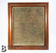
A charming George III silk work map of England and Wales, by Elizabeth Honeley 1784, stitched on linen, approx 40.5 x 49 cms, framed and glazed.
FRENCH REVOLUTION - LOUIS XVI Document signed and subscribed by the King ('Bon Louis'), and his secretary, ordering Joseph Duruey, Administrator o...
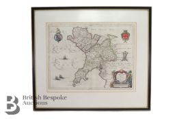
Johannes Blaeu, county map Comitatus Caernarvo: Niensis Vernacule Caernarvon-shire et Mona Insula vulgo Anglesey, approx 52 x 40 cms. (Map of Cae...
Yoshida Hiroshi (1876-1950) Chikugo River, 1927 Woodcut in colors on Japan paper, signed in pencil, titled and sealed Hiroshi and with the jizuri ...
Framed Fraktur Portrait of George Washington, America, mid-19th century. Equestrian portrait in blue, red, and black ink on trimmed sheet of wove...
Simeoni (Gabriel) Le sententiose imprese di... Paolo Giovio, et... Gabriel Symeoni, ridotte in rima per il detto Symeoni., first edition, collatio...
Speed (John) Wales, double-page hand coloured engraved map, inset views, Royal Arms, ships and sea-monsters, a further 12 views to the borders, J...
[Moulin (Pierre du)] Tragicum Theatrum Actorum, & Casuum Tragicorum Londini Publice celebratorum, printers woodcut device to title, 8 engraved por...
Streso (Caspar) Commentarius practicus in Actorum apostolicorum...capita priora sedecim, title with woodcut printer's device, a few instances of ...
(Anversa, 1682 - 1716)Veduta costiera con vascelli e figure Olio su tela applicata su tavola, cm 45,5X66Provenienza:Londra, Sotheby's, 13 luglio 1...
Corn growers & dealers.- To the Rt. Honble Wm. Pitt Chancellor of His Majesty's Exchequer. The Memorial and Petition of the several persons...bein...
A WWII Second World War British ' escape ' silk map of Eastern Europe & Greece sheets 43 H and G. Scale 1;100,000. Folds to pocket handkerchief si...
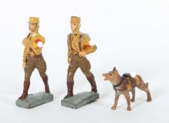
2 SA Soldaten mit HundLineol und Elastolin, 7,5-cm-Serie, SA, Lineol Fahnenträger ohne Fahne; Lineol Maschierer; Elastolin Sanitäts-Hund; min. Al...
Fuller (Thomas) The Holy State, second edition, engraved additional title and portrait illustrations by William Marshall, additional title soiled ...
Cochin aus Pufendorf„Mölln“ - Gesamtansicht über den Möllner See, im Vordergrund Reiterregiment, über der Ansicht Benennung der einzelnen Einheite...
Matthäus Merian(Basel 1593 - 1650 in Langenschwalbach, schweizerisch-deutscher Kupferstecher u. Verleger) „München - Monachium Regi Suecorum Certi...
Matthias Merian„Ratzebourg“, Bombardierung der Stadt durch die Dänen 1693, Original Kupferstich aus Merian's "Theatrum Europaeum“ um 1700, 18 x 23...
Stadtplan La Rochelle„Der Mächtigen und Vesten Statt Roschell wahrhafftige Abcontrafaktur“, Sebastian Munster 1544, aus Munsters Cosmographia, Ori...
Matthäus Merian„Plan der Bataille bey Gadebusch“ - Von denen Schweden unter Comando des H. General Stenbocks , über die Dänen u. Sachsen. Sieghaft...
Matthäus Merian(Basel 1593 - 1650 in Langenschwalbach, schweizerisch-deutscher Kupferstecher u. Verleger) „Gadebusch“, Origianal Kupferstich aus „...
Kupferstich Ratzeburg„Ansicht von Ratzeburg“ - Sr. Herzoglichen Durchlaucht dem regierenden Herzog von Mecklenburg Strelitz gewidmet von C.J. Erns...
Matthias Merian„Die Stadt Ratzeburg welche vom König von Dänemack Ao. 1693 im Monat Augusti bombardiret worden“, Original Kupferstich aus Merian's...
Gerdt Hane(Kupferstecher d. 16. Jh.) „Ratzeburgk“, Original handcolorierter Kupferstich aus Braun/ Hogenberg, verlegt Köln 1588, 33 x 40 cm, gerah...
This group of five antique engraved maps includes one color engraving in French of the Known World (Mappe-Monde ou Carte Generale de toutes les Pa...
(Anversa, 1708 - 1776)Adorazione dei MagiOlio su rame, cm 35,6X29,2Provenienza:Londra, Philips, 16 aprile 1991, lotto 114 (come Balthasar Beschey)...
LONDON STOW (JOHN) A Survey of the Cities of London and Westminster... Corrected, Improved, and Very Much Enlarged... to the Present Time; by John...
M.C. Escher "Ascending and Descending" Print Measures 9.5 x 12 inches Mounted to same size cardstock
John Rennell - 1792 - An 18th century engraving on paper map of the countries, situated between the source of the Ganges and the Caspian Sea. Publ...
(Anversa, 1620 - 1668) Ritratto di astronomo con sfera armillareFirmato in maniera indistinta in basso a sinistraOlio su tela, cm 42X34Provenienza...
A vintage early 20th century postcard album containing 90+ black and white and coloured postcards. Various views of mostly England comprising Wind...
DE SMET Fred (Frederic) get. 'Flotelle en mer, zeilboten op de zee' olie op doek | 65 x 85 - Afmetingen met kader 85 x 105
DELANGE Rob get. '77 'Winters hoevezicht' olie op doek | 50 x 50 - Afmetingen met kader 69 x 68
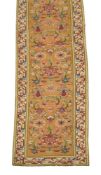
A LARGE SPANISH 'CUENCA' GALLERY CARPET Approximately 844 x 154cm Provenance: From a Private Collection, Berkshire, gathered over...
Schleswig Holstein. Nordfriesland. Original kolorierte Kupferstichkarte von Joh. Mejer aus C. Danckwerth, Newe Landesbeschreibung ..., 1652. 2 Kar...
Original antique map of the island of Santo Domingo on thick brown paper published months after Toussaint Louverture's War of the Knives rebellion...
DRIESSCHAERT H. get. Kunstmap met 15 lithografieën met inleidend woord van Gaby Gyselen + bijhorend mapje van Janssens Farmaceutica uitgegeven in ...
Beautiful antique hand-colored engraved map of England and Wales with part of Scotland including the new lines of canals, rail roads etc. Publishe...


![BLAEU (JAN) Delfi Batavorum vernacule Delft, [Amsterdam, 1649 or later]; BLAEU (WILLEM) Novus X...](https://portal-images.azureedge.net/auctions-2024/bonham10855/images/73460c6e-1380-48e8-bc29-b179011a54d5.jpg?h=175)


![SPEED (JOHN) Yorkshire; The North and East Ridins of Yorkshire; West Ridinges, [c.1730], hand-co...](https://portal-images.azureedge.net/auctions-2024/bonham10855/images/38d5b31b-fc81-4c30-82bb-b179011a54ac.jpg?h=175)


![[Moulin (Pierre du)] Tragicum Theatrum Actorum, & Casuum Tragicorum Londini Publice celebratorum,...](https://portal-images.azureedge.net/auctions-2024/forum-10424/images/b97cc6e6-3a73-4253-b964-b18600bc3202.jpg?h=175)